Late June 2013 had central and more southerly areas too hammered by an immense 'surge' flood with sustained heavy rainfall (it makes 2005 look easy). Researching some areas and feedback from outfitters, the damage is huge. Kananaskis Country virtually has no trail unaffected. Trailheads have disappeared, so too many bridges, access to some areas difficult if not impossible. Rainfall's often washed away topsoil even on trails away from creek and river crossings (the Powderface Trail is one such example, it could be renamed riding-on-stones!!). Water tables are right on max. which means muskeg areas are soggy plus.
End-August 2013 Update: For up-to-date information there is no better crew than the Barrier Lake Information in Kananaskis Country - wonderful people! Their telephone number is 403-673-3985.
They suggest also the constant updating on the government website at: http://www.albertaparks.ca/bow-valley-pp/information-facilities/kananaskis-contacts/barrier-lake-visitor-information-centre.aspx which usefully has its own search engine if you type (right-hand top side) what you're looking for.
Gillean and Tony Daffern operate a wonderfully up-to-date (by the day almost) blog for hikers, adjust your thinking a bit and it's useful plus too for equestrian users. Link at: http://kananaskisblog.com/ and there's also a Twitter feed at: https://twitter.com/KananaskisTrail
My own very limited observations as of 23rd August 2013 (I'm schooling horses at home, have fallen in love with long lining and bio-mechanics therapeutic horse work - and editing/media work! is my excuse!): -
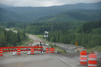 The Little Elbow Equestrian Campground is up and open and accessible by a one-lane replacement bridge just before Station Flats (which usefully tells you how many seconds you have to wait before the light changes to green). And yes, I know, the cracks on my windshield are getting interesting! The Little Elbow Equestrian Campground is up and open and accessible by a one-lane replacement bridge just before Station Flats (which usefully tells you how many seconds you have to wait before the light changes to green). And yes, I know, the cracks on my windshield are getting interesting!
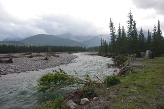
The day trailhead parking lot at Little Elbow now has the river a whole lot closer on its bottom sections! It's narrower, a bit faster and deeper and then you have about a third of a mile of ghastly glacier stones after that to clunk over to what was the 'other side'.
Deadfall everywhere, Cobble Flats was closed when I drove past (the river's route is way different too up and downstream). Elbow Falls - if you're sightseeing is much changed; I listened to one indignant tourist asking for it 'to be changed back' (true story, seriously!). Allen Pond is pure silt load.
 The Ford Creek Trail, and the 45 km. 'exploration and fire acces' 45-km loop trail are closed due to washouts and erosion. The Wildhorse Trail is open (I haven't ridden) though. Powderface is ..........rocky, let's put it like that. The little loop around the campground areas (southern side of the river) is compromised and closed. The pedestrian bridge is taped off. The northern loop area is washed stones and rock often with little topsoil - or else churned up clay now turning harder and lumpier. The Ford Creek Trail, and the 45 km. 'exploration and fire acces' 45-km loop trail are closed due to washouts and erosion. The Wildhorse Trail is open (I haven't ridden) though. Powderface is ..........rocky, let's put it like that. The little loop around the campground areas (southern side of the river) is compromised and closed. The pedestrian bridge is taped off. The northern loop area is washed stones and rock often with little topsoil - or else churned up clay now turning harder and lumpier.
At Mesa Butte, the super short little loop I loved for a quick outing or training young horses, namely along the creek eastwards and then up and over Curly Sands back to the day trailhead has, currently, serious deadfall to pick through along Three Point Creek sections. The 999, never my fav trail, is mud-stick-slop, with some areas under-run by springs sprouting in new places - mud can be hock-deep in those.
Windy Ridge going towards Death Valley has two very deep sections (hock deep clay-style holding mud as well as spring-fed-slop). |